
Traffic Data Collection: How Radar Sensors Turn Traffic into Real-Time Data
Traffic data collection provides the real-time information needed to understand how vehicles, cyclists, and pedestrians move through modern road networks. Radar traffic sensors continuously detect and track road users while providing data such as position, speed, direction, classification, lane assignment, and movement. This reliable data foundation supports smarter traffic management at intersections, on highways, and across connected cities.
Why Accurate Traffic Data Matters
Modern traffic management increasingly relies on automation, adaptive control, and connected infrastructure. But all these technologies depend on one fundamental resource: accurate, real-world traffic data.
A traffic system can only optimize what it can reliably detect. Without precise, real-time information about vehicles, cyclists, pedestrians, and traffic flow, downstream systems are working with an incomplete picture. Better algorithms cannot compensate for traffic events that were never detected or data that arrived too late.
This is why effective traffic management starts with reliable traffic data collection.
What Traffic Data Can Radar Sensors Collect?
Modern radar traffic sensors go beyond vehicle presence or simple traffic counts. They continuously detect and track individual road users, providing detailed real-time information about what is happening within the monitored area.
Position, Speed and Direction
Radar provides real-time object data such as position, speed, and heading. This allows traffic management systems to understand not only where an object is, but how it is moving.
At an intersection, for example, this information can show whether a vehicle is approaching the stop bar, slowing down, continuing straight, or turning.
Classification and Lane Assignment
Modern traffic environments include cars, trucks, buses, motorcycles, and Vulnerable Road Users (VRUs) such as cyclists or pedestrians.
Classification data helps distinguish between different types of traffic participants, while lane assignment identifies where individual objects are travelling. Together, these measurements provide detailed lane-level traffic data for traffic management and analysis.
Trajectories and Traffic Flow
Continuous object tracking creates trajectories that describe how road users move through the monitored area.
At intersections, these trajectories can support turning movement analysis for through, left-turn, right-turn, and U-turn movements. Combined with speed, classification, and lane information, they provide a detailed picture of how traffic flows through an intersection rather than simply how many vehicles pass a particular point.
From Individual Objects to Actionable Traffic Data
The value of traffic data collection is not simply the amount of information generated by a sensor. What matters is whether that information can support meaningful traffic management decisions.
Individual object measurements can be transformed into information such as vehicle counts, queue lengths, stop bar presence, turning movements, speed data, and lane-level traffic statistics.
This data can support adaptive signal control, congestion detection, vulnerable road user applications, traffic analysis, and long-term mobility planning.
The principle is simple: better traffic decisions start with a more accurate understanding of what is actually happening on the road.
Traffic Data Collection at Intersections
Intersections are particularly demanding environments for traffic data collection. Vehicles, cyclists, and pedestrians interact within a compact area, and the traffic situation can change within seconds.
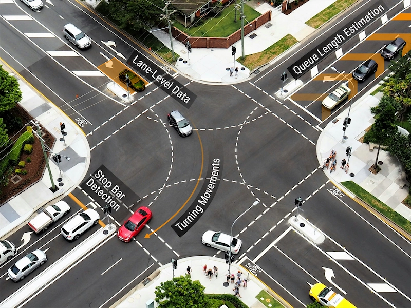
smartmicro radar sensors provide real-time detection, tracking, and traffic data for intersection management. Thanks to long-range detection, approaching traffic can be detected before it reaches the intersection, while a wide field of view enables multi-lane coverage and lane-specific detection across complex approaches.
Flexible detection zones enable different detection tasks, such as stop bar detection, advance detection, bicycle lane monitoring, and queue length estimation.
The resulting data can support adaptive signal strategies based on actual traffic conditions rather than static assumptions. Continuous trajectories can also provide turning movement data, helping traffic operators understand how traffic moves through the entire intersection.
Connecting Traffic Data with COM HUB
When multiple radar sensors are used at an intersection, COM HUB brings their data together within one traffic management system. The edge device synchronizes connected radar sensors and consolidates incoming data into a real-time object list, creating a unified source of traffic information rather than separate data streams from individual sensors.
This becomes particularly valuable at complex intersections, where several sensors may monitor different approaches. Object-based data can be provided to traffic controllers and ITS platforms through interfaces such as MQTT, enabling modern systems to work with real-time information about individual vehicles, cyclists, and pedestrians. In multi-sensor configurations, COM HUB can also support seamless tracking across overlapping sensor coverage areas, maintaining a consistent view of road users as they move through the intersection.
In this way, COM HUB connects radar-based traffic data collection with higher-level traffic management systems, turning data from distributed sensors into a scalable, real-time information source for intelligent traffic control.
Traffic Data Collection on Highways
Highways create different sensing requirements. Vehicles travel at higher speeds, several lanes need to be monitored simultaneously, and detection may be required over long distances.
Radar-based highway monitoring provides continuous information about individual vehicles, including position, speed, classification, lane assignment, and movement. This data can be used for traffic counting, speed monitoring, lane-specific traffic analysis, congestion detection, and broader traffic flow assessment.
Long-range, multi-lane detection also enables road operators to build a more complete real-time picture of highway traffic instead of relying solely on measurements from individual detection points.

Turning Traffic Data into Insights with smartmicro studio
Collecting traffic data is only the first step. Detection data from smartmicro sensors can be brought together in smartmicro studio for visualization, analytics, and reporting.
Real-time object information can be transformed into actionable traffic insights, helping users understand not only how much traffic is present but how it moves through the monitored area.
At intersections, this can include queue lengths, stop bar presence, vehicle counts, turning movements, and lane-level traffic data. Over time, collected data can support traffic analysis, signal optimization, planning, and Smart City applications.
By connecting radar-based detection with visualization and analytics, smartmicro studio turns sensor data into traffic information that can be evaluated and used for better decision-making.
Traffic Data Collection for Smart Cities
For smart city traffic management, reliable detection provides the data layer on which more advanced applications are built.
Real-time traffic data can support adaptive signal control, vulnerable road user applications, congestion management, connected mobility, and long-term transportation planning.
For example, an adaptive intersection can use current vehicle and queue information to respond to actual demand. Over longer periods, aggregated traffic data can reveal recurring congestion patterns, peak demand, road usage, and changing mobility behaviour.
Radar is particularly suited to this role because detection remains reliable regardless of lighting and under challenging conditions such as darkness, rain, fog, glare, and snow.
For intelligent transportation infrastructure, reliable sensing therefore comes before intelligent decision-making.
